Sarajevo Dobrinja — an invisible international border runs between two apartment blocks
The Inter-Entity Boundary Line — the Dayton internal border between the Federation and Republika Srpska — cuts through the middle of one Sarajevo neighbourhood. No fences. No signs. No guards. Residents have known it's there since 1995.
You can walk across an international border in Sarajevo without noticing. Not a joke and not an exaggeration. The border is legally there. It runs between two apartment blocks, ten metres apart, in the same residential neighbourhood, in the same country. There are no fences, no signs, no guards, and no customs. The people who live in the two blocks share a bus stop.
The neighbourhood is Dobrinja, and the border is one of the strange consequences of the Dayton Peace Agreement.
What Dobrinja is
Dobrinja sits south-west of Sarajevo’s centre, about five tram stops out. Builders raised it as a large 1980s residential district, twelve thousand or so apartments in prefabricated concrete slab-blocks, laid out on the same rational-modernist grid you find in Novi Beograd or Ljubljana’s Fužine. The reason it exists: the 1984 Winter Olympics. The athletes’ village, handed to the city as public housing at the end of the games.
Then the siege came. The Tunnel of Hope — the 800-metre passage under the airport runway — was dug nearby, connecting besieged Sarajevo to the free territory through Dobrinja’s adjacent municipality.
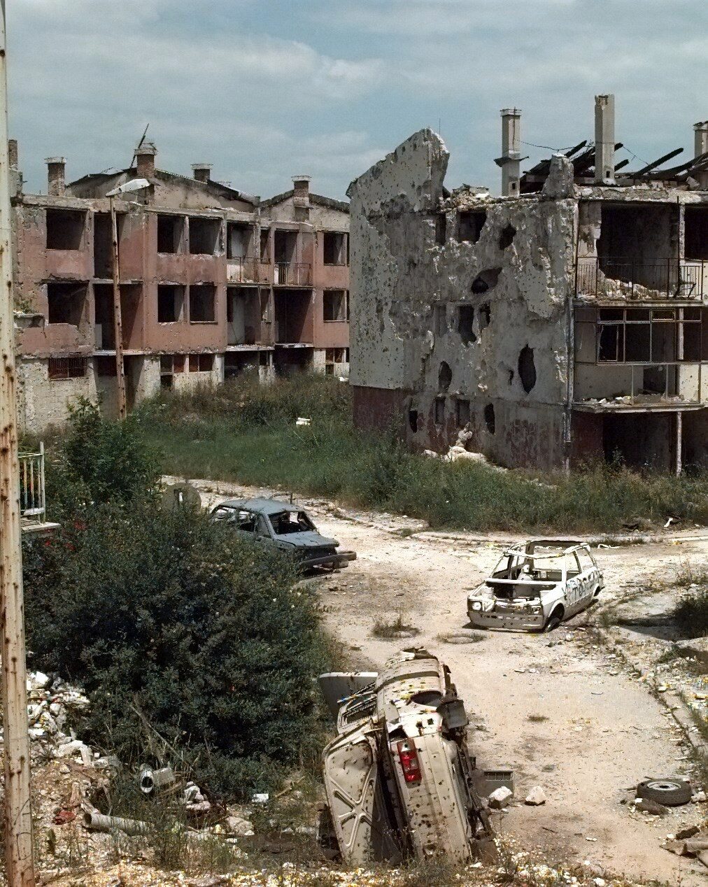
Between 1992 and 1995, Dobrinja sat directly on the front line. Some of its blocks were held by the Army of Bosnia and Herzegovina; others were held by the Army of Republika Srpska. The line of contact ran through the neighbourhood. Streets that had been ordinary bus corridors became sniper alleys. Blocks that had faced each other across a courtyard now faced each other across a war.

What Dayton did
The General Framework Agreement for Peace in Bosnia and Herzegovina, the Dayton Accord, signed at Wright-Patterson Air Force Base in November 1995 and formally in Paris on 14 December 1995, ended the war. It also split the country into two “entities” of roughly equal size:
- The Federation of Bosnia and Herzegovina (Bosniak-Croat majority, controlling about 51% of the country’s territory).
- Republika Srpska (Serb majority, controlling about 49%).
The line between them is the Inter-Entity Boundary Line (IEBL). As a matter of Dayton mathematics, the IEBL has no international standing — a domestic administrative border inside one sovereign state. But as a matter of lived reality it is a working boundary between two administrative jurisdictions with separate police forces, separate school curricula, separate license plates, separate healthcare systems, and separate parliaments.
The IEBL doesn’t run around the outside of Sarajevo. It runs through Sarajevo. Specifically, it runs through Dobrinja.
What the border looks like
The Romanian political scientist Miruna Troncotă, in a 2015 paper on Sarajevo as a border city, sends her reader to one corner of Dobrinja: two apartment blocks facing each other across a courtyard. One is in the Federation. The other is in Republika Srpska. Ten metres apart. Same building type, same 1980s design, same balconies, same paint colour, same washing lines. The people living in them share the bus stop out front.
The anthropologist Stef Jansen has spent years doing ethnographic fieldwork in Dobrinja. His 2013 paper, cited in Troncotă, describes what the border actually feels like on the ground: “a deeply contested polity border, invested with considerable sovereignty claims, governmental logistics and affect.” Which is academic language for: it’s an international border of sorts, and it’s between two apartment blocks in a working residential district that visitors can walk through without knowing they’re doing it.
You cross the IEBL and:
- Your kids’ school switches curriculum (Federation or Republika Srpska).
- The colour of your license plate technically changes.
- The tax authority you owe changes.
- The police force that patrols the street changes.
- The company that supplies your electricity may change.
- The postal code changes.
- Your address changes even if your building didn’t move.
None of this is signposted at street level. There is no fence. There is no customs. There is no toll. The bus that runs down the road runs into both entities on the same route. The neighbourhood-scale infrastructure was never rebuilt around the border because the border was never treated as an actual border in Dobrinja itself.
But it’s there. Ask a resident. They know.
What that means, day to day
Jansen’s fieldwork records what most travel writing about Sarajevo doesn’t touch: the everyday ways people manage a border that officially doesn’t need to be managed.
Kids go to a school in the entity their family chose, not necessarily the one their block sits in, because families have views on which curriculum will get them further, and because the border is close enough that both are walkable. Younger residents are less likely to know exactly where the line runs on their block than older ones. Property values are meaningfully different on the two sides of the same street, because the different entities have different property-tax regimes, different post-war restitution logic, and different secondary markets.
A 30-year-old office worker interviewed by another researcher (Ademović 2025, at the Faculty of Political Sciences) describes his commute from Dobrinja to central Sarajevo as 60–70 minutes by public transport vs 20 minutes by car early morning. The reason is partly that the two entities co-manage the transit corridor through the neighbourhood — one bus company on one side, another on the other, with a required interchange at the boundary line — and the inefficiencies of that arrangement land, disproportionately, on the residents who cannot afford a car.
One resident of the Federation side of the line put it this way: “We know where the border is. We don’t talk about it. The tram tracks don’t stop at it. But when there’s a football match on TV and Republika Srpska is playing, my neighbours across the courtyard are cheering different.”
What to do with this
If you’re a first-time visitor to Sarajevo, you’re not going to Dobrinja. It’s a residential neighbourhood, not on any walking tour, no particular sight to see. Tram 3 goes there but nobody gets off. You will fly into or out of the airport ten minutes from Dobrinja and never know.
But if you have been to Sarajevo twice already, and you want to see the version of the city that most guidebooks don’t describe — the one where the international consequences of the 1992–1995 war are still built into the physical infrastructure of daily life — take tram 3 to Dobrinja Centre, get off, walk the block grid for an hour, and look at the way two apartment complexes ten metres apart can belong to two different administrative universes.
No signage. No dramatic moment. The point is that there isn’t one. The border is where it is because Dayton put it there in 1995, and Dobrinja has been slowly figuring out how to live with it ever since.
If you want to read Jansen’s paper before you go, and you should, it’s in Social Anthropology 21:1 (2013). Troncotă’s summary in Eurolimes 19 (2015) is the shorter English-language version.
And when you’re standing on that street corner, thinking about the fact that you’re crossing an internal international boundary just by walking, remember what Jansen writes: the thing that makes a border a border is not what it looks like on the ground. It’s what it does to the people who live around it.
Dobrinja is a working test of that idea. Everybody there knows the answer.
Sources & further reading
- Miruna Troncotă, 'Sarajevo — a border city caught between its multicultural past, the Bosnian war and a European future' — Eurolimes 19 (2015)
- Stef Jansen, 'People and Things in the Ethnography of Borders' — Social Anthropology 21:1 (2013)
- General Framework Agreement for Peace in Bosnia and Herzegovina (Dayton, 14 December 1995), Annex 2 (IEBL)
Keep reading
More from the guide.

Sarajevo Inat — the Bosnian word for stubbornness with honour, and the house dismantled beam by beam
Inat does not translate. The closest English word is stubbornness, but inat is stubbornness with honour. The most famous example in Sarajevo...
Sarajevo — Neidhardt's archive burned in the siege, and MoMA bought what survived in 2021
The Grabrijan and Neidhardt story tells you how the two Yugoslav architects wrote the 1957 book that redefined Bosnian modernism. What it...

Sarajevo — the Vogošća trolleybus came back in 2024, after 28 years off the map
If you take the cable car up Trebević and look north across the valley, you’ll see a suburban district climbing the far...