Explore Sarajevo / Destinations / The Olympic Bobsled and Luge Track
Destination · Trebević · 5 min read
The Olympic Bobsled and Luge Track
The 1,300-metre track on Trebević built for the 1984 Winter Olympics, abandoned in the 1992–95 siege, now a graffiti-covered ribbon of concrete winding down through the pine forest.
- Established
- Track completed 1982; Olympics 1984
- By
- Project led by the Sarajevo Olympic Committee; design by the Sarajevo Institute of Architecture
.jpg)
Address
Mount Trebević, accessed from the upper cable-car station (Vidikovac)
Hours
Always accessible. The cable car runs roughly 10:00–18:00 (longer in summer); verify seasonally.
Price
Free to walk the track. ~20 BAM (~€10) return for the cable car.
Getting there
Sarajevo cable car (donja stanica at Hrvatin 92, Bistrik) to the upper station; about 15-minute ride. Then a 5-minute walk south along the marked trail to the track.
Time needed
1.5–2 hours including walking the full 1,300 m of accessible track, plus the cable-car ride each way. Half a day with stops.
Best time
Late spring through early autumn. The track is at ~1,160 m, often snowed in from December to March.
Coordinates
43.8417° N 18.4587° E
Navigate
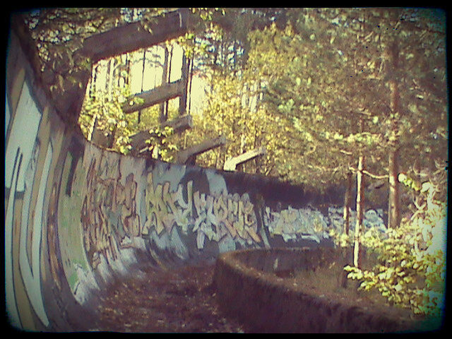
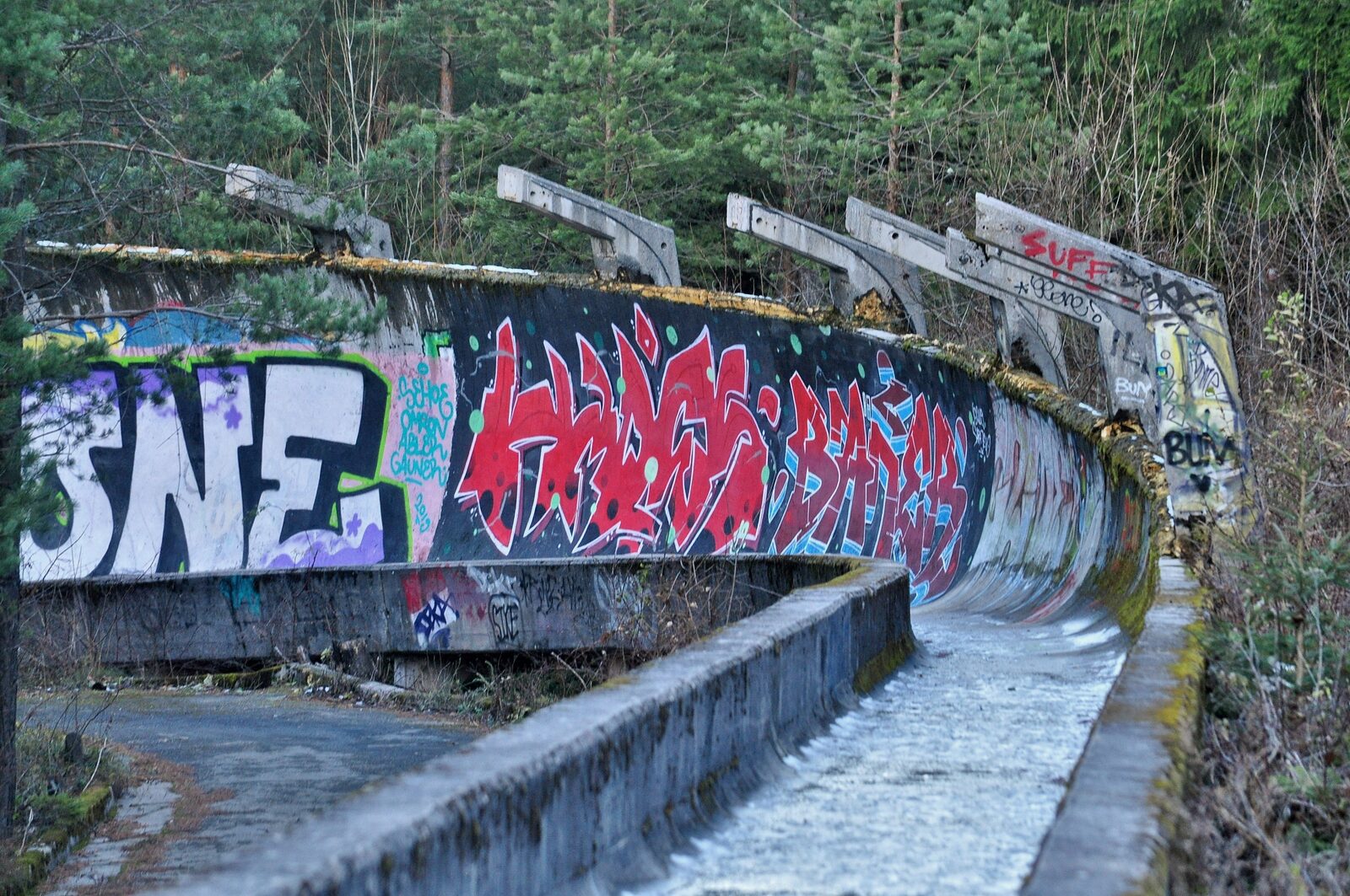
The Sarajevo Olympic Bobsled and Luge Track is a 1,300-metre concrete ribbon that winds down the northern slope of Mount Trebević, from a starting house at roughly 1,160 metres elevation to a finish house about 130 metres lower. It has thirteen curves, was completed in 1982, and was raced for the first time at the 1983 European Bobsleigh Championships. At the 1984 Winter Olympics, it staged the bobsled and luge events. After the Olympics, the track hosted World Cup events through 1991, the year before the war began.
The 1992 to 1995 Siege of Sarajevo is where the track’s editorial story turns. Bosnian Serb Army forces controlled the surrounding mountains and used the upper sections of the track as a mortar position — a hardened concrete trough above the city is, by accident, an excellent military emplacement. The track was shelled in turn. By the time the siege ended in 1995, the structure was extensively damaged, the surrounding forest was mined, and the surrounding ski infrastructure on Trebević (chairlifts, cable cars, mountain stations) was destroyed. Trebević itself remained closed for years afterwards because of mine clearance.
The track has never been restored to competition standard. In 2016, the city undertook a partial structural repair — enough to allow modern bobsled teams to use sections of it for low-speed training — but the visible character of the track has been left as it was. The graffiti has accumulated since the late 1990s. The structure is now, in a strange double sense, a public monument: an Olympic ruin and a constantly-evolving piece of street art.
How to walk it
The standard sequence:
- Take the cable car (Trebevićka žičara) from the lower station at Hrvatin 92 in Bistrik. The lift was originally built in 1959, destroyed in the war, and reopened on 6 April 2018 after a Swiss-funded reconstruction. The ride is about 15 minutes; the views over Sarajevo opening out below are the first reason to make the trip even without the track.
- From the upper station (Vidikovac), walk south on the marked path. The starting house of the track is about five minutes’ walk.
- From the starting house, walk down the track itself. The concrete is broken in places; the bracing and sleepers are still visible; the curves get progressively tighter. Curve 11 is the tightest and the most photographed.
- The walk down the full track takes about 45 minutes at a slow pace. Return either by walking back up the track (about an hour, depending on stops), or by taking the lower walking trail back to the cable-car upper station.
Practical notes
The single safety concern is unexploded ordnance in the wider Trebević forest. The walking path and the track itself have been cleared and are safe. Do not stray into the forest off the marked path, in any direction, even where it looks like a tempting shortcut. The mines that remain are not always visible. The official advice — which has been consistent since 1995 and remains so — is: stick to the path, stick to the track, do not wander.
Beyond that, the visit is straightforward. The track is open all year, weather permitting; late spring through early autumn is the comfortable window. In winter the track is often snow-covered and slippery, though some visitors do walk it in fresh snow as a different kind of experience. The cable car runs throughout the year; verify the day’s schedule before you go.
At the upper cable-car station there is a café with food and drinks (Vidikovac) and, on weekends in summer, food trucks in the parking area. The cable-car ticket includes the return journey. Allow half a day for the full experience: the cable-car ride, the track walk, a coffee at the upper café, and the cable-car return.
What else is on Trebević
The bobsled track is the most-cited reason to come to Trebević, but it is not the only one. A short additional walk from the upper cable-car station gives you:
- The Trebević summit ridge (1,627 m) — the highest point in the immediate Sarajevo basin, with views east toward Romanija and west toward the city.
- The remains of the Čolina Kapa Astronomical Observatory, operated by the Sarajevo Astronomical Society from 1972 until its destruction in the war.
- The ruined Austro-Hungarian fortifications scattered along the ridge, from the 1878–1918 period when the empire built a chain of small redoubts above the city.
- The forest itself, replanted in the 1950s as a state forestry project, and the bird and small-mammal life that has returned in the years since 1995.
For the full destination entry on Trebević, see Trebević and the long-form story Sunset on Trebević: the nine-minute commute to a different world.
A note on the documentary
In 2024 the British filmmaker David Whelan released a short documentary called The Track, about the bobsled track and the graffiti artists who have adopted it as a canvas. The film runs about 23 minutes and was widely shown at European documentary festivals through 2025. If you can find a copy, watch it before going — it will change how you read the surfaces. (Our notes on the film are at The Track — a documentary about the Trebević bobsled run.)
The geometry, in two paragraphs
The track is a single continuous concrete trough, semi-circular in section, around 1.4 metres wide. The curves are reinforced with outer walls of about 4 metres high at the steepest banking; the straights are lower. The total drop from start to finish is 130 metres over 1,300 metres of track, giving an average gradient of 10%. The 13 curves are numbered sequentially down the run; the design was modelled on the Igls track in Innsbruck (used in the 1964 and 1976 Olympics) and the Lake Placid track in upstate New York.
In its working life from 1982 to 1991, the track produced the bobsled and luge times of an Olympic Games, two World Cup seasons, and several European championships. The fastest recorded run, in the four-man bobsled event of the 1984 Games, came in at around 0:49.21. The Olympic bobsled (West Germany) and the Olympic luge (East Germany) winners are listed at the start of the track on a small bilingual plaque, still legible under the graffiti.
In its current life — about three times longer than its working life — the track has been a sniper position, a mortar emplacement, a mine field’s edge, a sculpture garden, a film location, a hiking trail, a graffiti canvas, and an open-air Olympic memorial. It is one of the more affecting twenty-minute walks in Europe. Take water.
Sources & further reading
More views
From The Olympic Bobsled and Luge Track
Photographs: isaleal · source · CC BY 2.0
.jpg)
Keep wandering
Nearby & related
See on the map →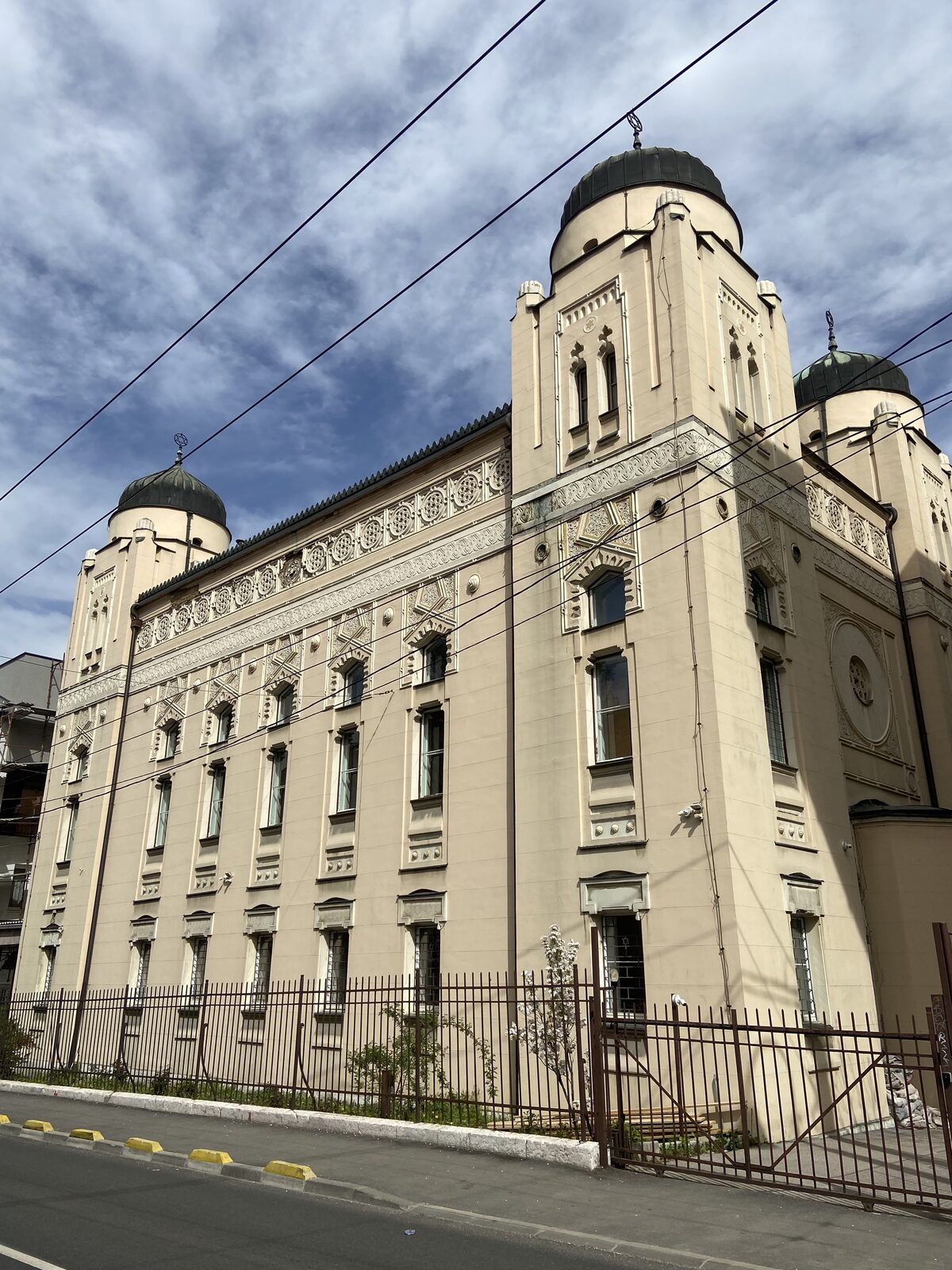 Ph: Desemeus · CC BY-SA 4.0
Hrid / south bank
Ashkenazi Synagogue
Sarajevo's working synagogue, built in 1902 in pseudo-Moorish style by the Austro-Hungarian administration for the Jewish community that had grown rapidly after 1878. Survived the Holocaust as a building, if not as a community. Still active. Friendly to visitors.
Open the destination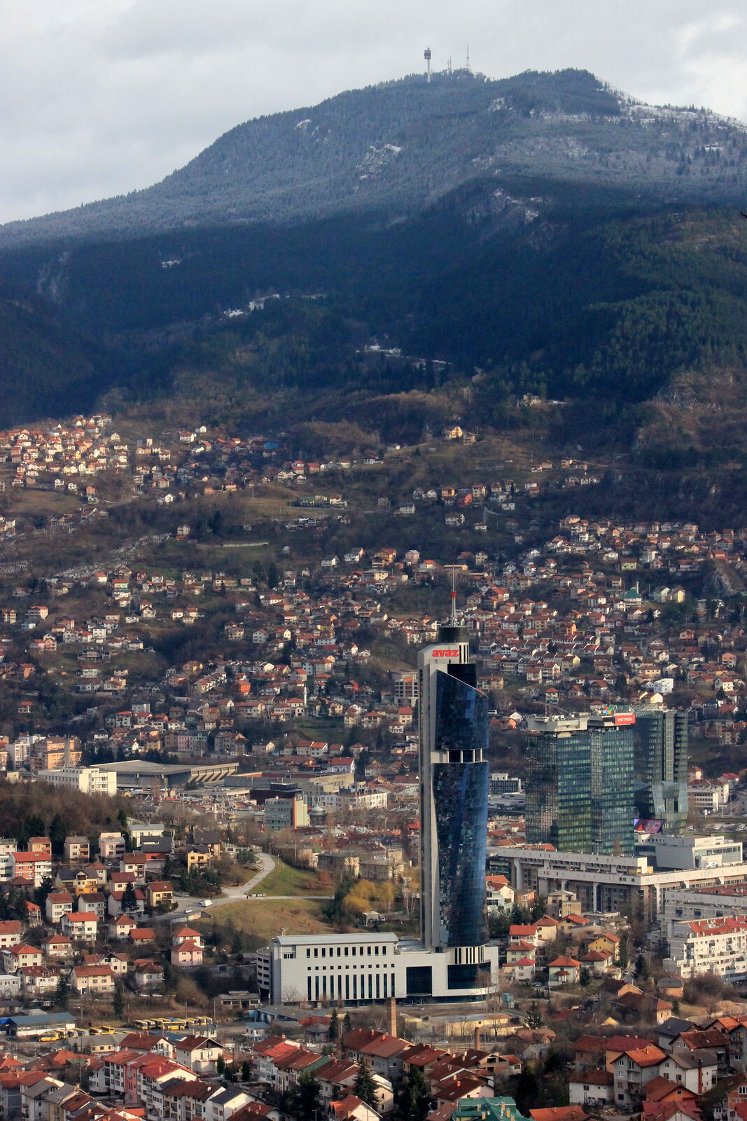 Ph: Julian Nyča · CC BY-SA 3.0
Marijin Dvor / Centar
Avaz Twist Tower
The Avaz Twist Tower is Sarajevo's tallest building (142 metres, completed 2008). A small public observation deck on the 35th floor costs around 5 BAM and gives you the full valley. Skip the café at the top. Take the view.
Open the destination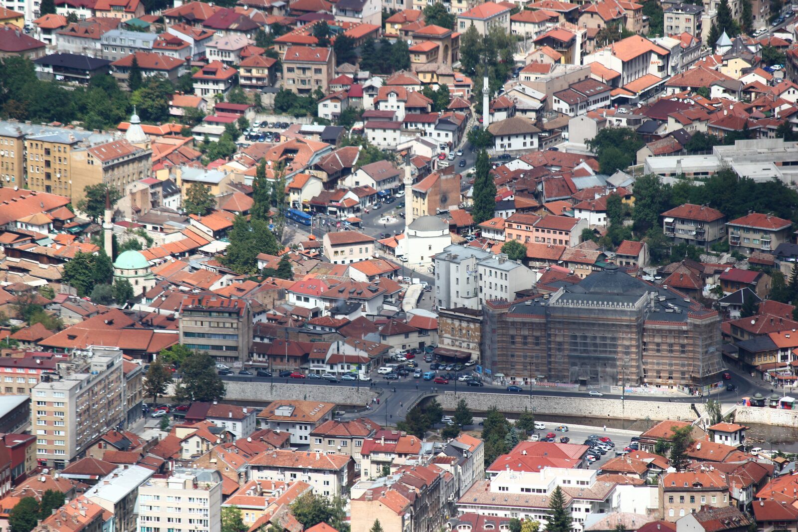 Ph: Julian Nyča · CC BY-SA 3.0
Stari Grad
Baščaršija
The 1462 Ottoman bazaar of Sarajevo, still a working bazaar. Copper workshops on Kazandžiluk, Bosnian coffee at Morića Han, and a marker in the pavement where the Ottoman city meets the Habsburg one.
Open the destination